After a wet September in North Florida, area farmers were treated to a dry October with near perfect harvesting conditions. Many have gone out of their way to remind me I thought we could expect a cooler, wetter fall because of the conditions climatologists have called “Super El Nino.” I’ve heard enough jokes about guys putting new wiper blades on their trucks, only to have them dry rot in the sun, that it’s actually not very funny anymore. Because of the recent dryness, I am hearing about some challenges to dig peanuts in soils with higher clay content, and winter grazing crops still in the bag until adequate moisture is received for planting.
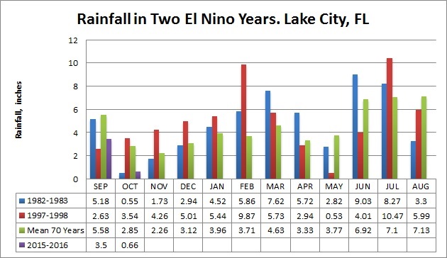
Climatologists have used a couple analog years for comparison to this super el nino year. The winters of 1982-1983 and 1997-1998 have been reported as years where El Nino conditions intensified rapidly and to a high level, such as this the climatologists are reporting this year. My curiosity led me to dig into the long term rainfall data to look at those years more closely from a local rainfall perspective. Thanks to the Suwannee River Water Management District staff for providing data from the Lake City station, near the Lake City Airport. This location had 70 years of rainfall history.
Examining these two analog years, both had above average rainfall for the periods from October through May. However, 1982 was wet in September, followed by below average rainfall in October, November, and December. Rainfall in 1983 was above average from January through April. Historical data show a slightly different pattern for the 1997-1998 fall and winter. September was drier than average in 1997, giving way to above average rainfall from October through March. Locally, it appears that conditions have mirrored those of the fall of 1982. Perhaps this winter will shape up to match the winter of 1982-1983 more closely. Local farmers are optimistic to receive a couple more weeks of dry, sunny weather to finish harvesting their field crops. Then we can expect a high likelihood of below normal temperatures, and above normal rainfall.


good post mace. my Jefferson county farmers are not joking about el nino. we expect el nino effects to start around nov 1 and a sign of what may be coming came last nite in Jefferson county and brooks county. anywhere form a trace to 6 inches of rain from 7:00 PM to 11:00 PM.. with 5 soybean growers with 1000 + acres of beans to harvest and one grower with 600 acres of cotton to harvest, last nite and predicted rain weather next 7 days does not bode well.
I’m optimistic that good weather hangs in through November, Joel. Would have never guessed it rained like that here 50 miles away.
It all came here to SC
Sorry to see all the losses in South Carolina Neal. Another season of extremes it looks like.